
Crop
SarVision’s SarAgri system enables monitoring crop growth (incl anomalies such as storm and flood damage, diseases, etc), crop extent, crop height and harvest forecast
Our products support:
-
Digital farming services.
-
Sustainable agriculture & food security policies.
-
Agri-businesses.
-
Agri-Finance and insurance services.
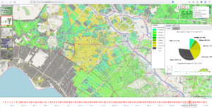
The above image shows the rice growth stages in one moment of time on our online rice monitoring platform that we developed for the Mekong delta in Vietnam. New maps are updated every 6 days and show:
– The rice crop extent and growth stage of the rice (seedling, tillering, booting, flowering, milking, ripening, harvesting, fallow)
– The flooding extent
– Crop height
With help of the viewer and analysis tool statistics can be calculated on the fly for the rice area extent, growth stage, and crop height for every date (see pie charts)
The Sat4Rice project aims to improve the effectiveness of existing extension services and output of (smallholder) rice farmers in the Delta. This is done by enriching the existing basic agricultural information with advanced geodata. Crop growth stage maps and floods maps are combined with in-situ data in a mobile application used by fields officers to provide more effective advice to smallholder rice farmers
We implemented several agricultural monitoring projects in the world. From 2018-2021 a near real time rice crop growth stages monitoring system was implemented in Myanmar (15m, 12 day interval). We recently also successfully tested crop, biomass and periodic wetness monitoring of agricultural fields in the Netherlands. In previous years we developed crop monitoring systems for Vietnam, Bangladesh, Pakistan, Tanzania and Indonesia.
SarVision can identify, map and monitor agricultural crops and other land use types near real time, anywhere and anytime.
For a video presentation of the SarAgri system with crop monitoring animations click on the figure above.