The need to monitor forests
Newspapers report almost every day about threats to forests all around the globe. Climate change results in large wildfires and pressure on land and resources lead to forest conversion at a large scale. But forest loss comes at a cost. The losses contribute to the increase of global carbon emission, ecosystem goods and services diminish, and remaining biodiversity is decreasing at an alarming rate.
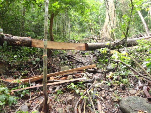
While part of the forest loss is policy driven, a significant reduction is caused by illegal activities. As these occur often in large and remote areas, satellite-based monitoring is required. Due to frequent cloud cover the use of radar images that can ‘look’ through clouds is essential for a near real time monitoring of these threats.
With SarVision’s automated Near Real Time Forest Monitoring System, forest changes are mapped for very large areas every 6 or 12 days at a resolution of 15 meter. Not only clear-cut areas but also forest degradation, canal and road development, floods and forest fire scars are mapped. Costs are low as use is made of free of cost radar imagery. The system allows quick response actions within two days after an image has been acquired by the satellite.
Recently we we developed the integrated SarSentry forest monitoring system that includes near real time monitoring of forest degradation so that not only deforestation is automatically mapped every 6-12 days, but also forest degradation that is not detected by any other wide area monitoring system in the world yet! As forest degradation can be responsible for more than 50% of the total forest and biomass loss, this aspect is also very relevant for early warning systems and carbon credit assessments.
SarVision’s forest monitoring systems are operational in several parts of the world (e.g., entire Borneo, Guiana’s, Colombian Amazon, Paraguay, Indonesia, Philippines, Guinea, East Africa) and can easily be upscaled to any forest area in the world. With each orbit of the satellite we are able to detect deforestation everywhere.
Near real time forest monitoring
SarVision developed a Near Real Time (NRT) forest monitoring system based on a combination of free of cost Sentinel-1 radar data and L-band PALSAR data. Not only large-scale logging can be monitored, but also small scale forest degradation (!), floods, forest fire scars, and canal and road development.

The advantage of this system in comparison to current optical-based monitoring systems is that forest change maps can be produced every 12 days with a high resolution of 15-m, and at low cost. Optical images are only sparsely available for this type of tropical forests because of a frequent cloud cover or the presence of smoke and haze. Therefore, part of the deforestation is monitored by optical systems only months after the damage has occurred. But this is not the only advantage of using radar. Radar can see more than optical systems. It can detect forest degradation caused by selective cutting which is often not picked up by optical systems due to the large time lags in available optical images and regrowth of fast-growing pioneer species that fill in the gaps. But forest degradation is an important indicator of current and future forest loss and also strongly related to a decrease of biodiversity and carbon stocks.
In addition, L-band radar is able to penetrate the forest canopy and with the help of SarVision’s advanced algorithms it is possible to monitor floods and soil moisture conditions under the tree crowns. A feature that is not possible with optical images. Note that this system is also able to detect drying out of peat forest areas and it is even possible to locate defective dams in former drainage canals that start draining the peat forest again, which leads to drought. Using this system will support fire prevention measures and will lead to huge amounts of avoided carbon emission in peat forests, especially in El Niño years.
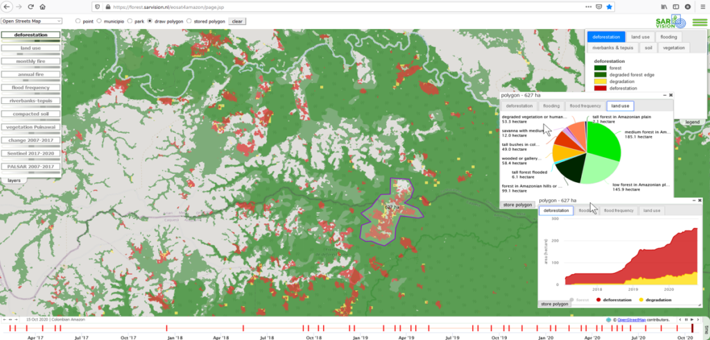
Based on the expertise gained by SarVision with its earlier projects in Kalimantan, SarVision developed a fully operational and automated NRT forest monitoring system called SarSentry. This system uses free of cost Sentinel-1 data. The change detection products of this system are used by WWF for the development of its Early Warning System. Information of this system is used for the development of a predictive forest degradation model based on machine learning. The NRT forest monitoring system is now operational for entire Borneo, Surinam, Guyana and Colombian Amazon. Thanks to SarVision’s advanced computer systems and expertise in cloud computing, the monitoring systems can easily be upscaled to other forest areas in the world.
NRT monitoring allows governments to act immediately, e.g. to send out direct response intervention teams in case of illegal deforestation. Sentinel-1 data are available from 2015 onwards and also future availability of L-band data is secured by new satellites that will become operational in the next few years (e.g. NISAR). The flow of future C-band radar data is secured by ESA for at least 20 years to come. SarVision not only provides NRT monitoring products to clients anywhere in the world, but also offers a technology transfer so that the system can be applied and validated by local remote sensing agencies themselves. This provides a legal status to the monitoring products which enables authorisation of intervention activities by national and local government authorities.
A recent scientific publication about Near-Real-Time monitoring of Tropical Forest Degradation and Deforestation by D Hoekman can be found here
Tree monitoring system
Next to its forest monitoring systems, SarVision developed a Tree Monitoring System that detects small-scale encroachment and maps individual tree felling at a resolution of 3-m, independent of cloud and haze conditions. SarVision developed and operationalized this system for test areas in the State of Pará in Brazil using a combination of TerraSAR-X, PALSAR and Sentinel-1 radar imagery. The semi-automated tree monitoring system is very accurate and can be set to a high temporal frequency (11 days) or with a lower frequency as requested. The system can easily be upscaled to any other forest area in the world.
If you are interested to read more about our forest monitoring products, please download our forest monitoring factsheet here
Integrated monitoring systems
SarVision offers a multi-scale approach that complements current (optical) based systems. Radar monitoring products can be produced in such a format that they can easily be integrated with the existing monitoring products. Radar monitoring is able to increase the monitoring frequency in frequently clouded areas and can be used to monitor additional aspects that cannot be detected by optical systems alone. As high-resolution imagery is in general very costly, the radar monitoring component can also be used to localize priority areas where important changes are occurring. This will significantly reduce costs for the purchase of optical imagery.
The SarSentry monitoring system is also combined with the SarCarbon system for mapping biomass and carbon. Not only carbon baseline maps are made with an accuracy that outperforms other existing Remote Sensing based carbon assessments, but the SarCarbon system also generates periodical biomass and carbon change maps, even at near real time!
The SarSentry forest monitoring system can also be combined with the SarAgri crop monitoring system to monitor the full spectrum of land use classes, including the growth and extent of agricultural crops. SarAgri is also able to measure crop height and provide harvest forecast information. But the system is also able to detect anomalies such as storm and flood damage, diseases, etc.
The forest monitoring systems are combined with our SarEcomap tool that is used to make a detailed landuse map of a region based on a combination of radar and optical imagery. SarEcomap is used for the development of our SarSentry baseline map. SarEcomap is also used for the quantification of land use changes, e.g. mapping of agricultural expansion.
Our SarAgri system can also be integrated with our latest SarSoil soil degradation monitoring system. With this system it is possible to detect and map soil degradation as a result of soil compaction by e.g. cattle.
The monitoring systems can also be combined with our advanced SarFlood system. With the SarFlood system floods can be mapped and monitored, even under the forest canopy! Next to the assessment of current and future flood damage, the impact of drainage in agriculture fields on surrounding nature can be quanitified
With help of the integrated monitoring system it is possible to monitor certified concession owners and farmers. The output can be used to provide evidence for Agribusiness companies that want to take care that the products they use or deliver are produced in line with the certification criteria regarding deforestation restrictions.
Our monitoring systems are integrated with our online WebGis viewer and analysis tool that can be accessed by any viewer that has been granted access. Alerts are generated automatically, based on criteria that have been drafted by stakeholders during special participatory events.
We also developed an interactive mobile app that can be used by local stakeholders to upload photographs and a report to the monitoring system so that information on (illegal) activities can be linked to the forest change maps. As wireless connections are sometimes poor in many forest areas, the app also works off line.
SarVision is also specialised in Capacity Building related to Remote Sensing applications and has offered many training programs in several countries all over the world. Previous collaboration with KLHK and LAPAN in Indonesia has shown that operational technology transfer and effective institutional capacity building is very well possible. Similar approaches can be applied elsewhere.