
SarSoil
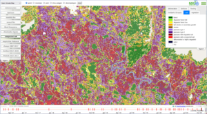
SarVision developed a radar based monitoring system that is able to map soil compaction. In North West Colombian Amazon deforestation is followed by agricultural and ranching activities leading to land abandonment due to soil degradation. This land degradation process pushes the ranchers to deforest further in search of new “fresh” soils. This practice has become one of most important deforestation and degradation drivers in the region. The combination of the Sentinel-1 time series of images in combination with the vegetation stratification made with Palsar data, allows the detection of areas where soil compaction in grasslands occur.